
Assistant Information Officer
Department of Information & Public Relations
Telephone: 468-2740
Email: bmckelly@gov.vg
Photo and Caption
Photo and Caption
Town and Country Planning Department
Release Date:
Thursday, 19 November 2015 - 5:15pm
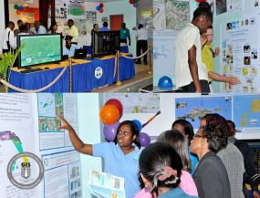 Persons learned more about the use and applications of Geographic Information Systems (GIS) in planning and development throughout the Territory during an interactive display at the Central Administration Complex where they engaged with various exhibitors including the Inland Revenue Department, Land Registry, the Water and Sewerage Department, along with the National Parks Trust. The event was held as part of observances for the 16th Annual World Geographic Information Systems (GIS) and Town Planning Day on November 18 by the Town and Country Planning Department and the National Geographic Information Systems Steering Committee. Held under the theme, “Discovering the World through GIS and Planning”, the event was designed to educate the public on the planning and building requirements of the Territory, along with various real-world applications in the use of Geographic Information Systems (GIS). (Photo Caption: Franklyn Skerritt/GIS)
